
Redland City Council wants public input to its long term planning for coastal hazard adaptation for future sea level rises and storm events which may cause erosion and inundation.
Key State Government assumptions factored into this planning work are that over the next 80 years the sea level will increase by 0.8 metres and cyclone intensity will increase by 10%.
With up to $500,000 funding from the State Government, the Council’s eight phase project known as the Coastal Hazard Adaptation Strategy (CHAS) will
- identify coastal hazard areas
- understand vulnerabilities and risks to a range of assets and values
- engage with the community to understand their preferred approach to adaptation
- determine the costs, priorities, and timeframes for their implementation.
Mayor Karen Williams said the strategy is being developed in consultation with the Quandamooka Yoolooburrabee Aboriginal Corporation (QYAC), key asset owners and stakeholder bodies, and the wider Redlands Coast community.
“The next phase of the CHAS calls for the community to provide invaluable input to help inform the strategy’s recommended actions”, she said.
Information about the CHAS is available on Redland City Council’s website.
Community feedback on options for adapting to coastal hazards is now being sought via an on-line survey to be completed by 24 July 2020.
If you think the survey does not allow adequate opportunity to have a say about this important issue, you could send a written submission or comment to the Council.
Written submissions would be a way of commenting on issues such as:
- Risks of plans to construct 3,600 apartments on land reclaimed from Ramsar wetlands between the Grand View Hotel and Toondah Harbour
- The prospect that sea level rises could significantly exceed the assumed increase of 0.8 meters by 2100
- Alignment of coastal hazard adaptation strategies with Redland City’s long term community plan
To have your say with a written submission, send an email to rcc@redland.qld.gov.au and mark it:
Submission about Coast Hazard Adaptation Strategy Phase 6
You could send a cc copy to one or more elected councillors to ensure that they are kept in the loop.
Coastal hazard adaptation is necessary
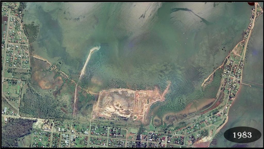
Coastal areas of Redland City are under pressure from changing land use caused by relentless regional population growth over many decades.
Global warming is expected to result in sea levels increasing which will have a significant impact on Redland City which has over 300 kms of cosatline.
Redland City Council has used a projected sea-level rise figure of 0.8m for the year 2100. This is in line with the State Government’s coastal hazard projected sea-level rise figure for the year 2100 of 0.8metre which came from the CSIRO’s Climate Change in Australia project.
Potential hazards are coastal erosion, storm tide inundation, storm surge and sea-level rise to the end of the century. This project is focused on the years 2070 to 2100.
There are significant implications predicted to arise from the severity and incidence of cyclones with the expected reach of cyclones moving south.
Governments now have to deal with the legacy of planning decisions made many years ago such as building canal estates in areas which used to be wetlands, such as Raby Bay.
Coastal hazard adaptation options
Likely adaptation options fall into one of five broad categories:
- Defend
- Accommodate
- Retreat
- Status quo
- Repurpose.
In its Frequently Asked Questions, the Council says:
“Adaptation options developed by Council will, however, only be for public assets. Private landowners would need to carry out and fund their own adaption option, subject to the normal Development Approval process.”

The Community Plan and coastal hazards
The Redlands Community Plan addresses coastal management issues:
- Healthy Natural Environment
- Embracing the Bay
- Quandamooka Country
- Wise planning and design
This community based plan should be reconciled with any strategies developed for dealing with coastal hazards.
The Toondah Harbour coastal hazard
In November 2014, two months after Walker Group was selected as the preferred developer of apartments on wetlands in the Toondah Harbour, Priority Development Area, the LNP’s Deputy Premier and Planning Minister Jeff Seeney directed that “any assumption about a theoretical projected sea level rise” be removed from the Moreton Bay Regional Council’s new planning scheme.
This ministerial direction caused alarm among planning experts, the Local Government Association, SEQ Council of Mayors and individual Councils alike. His direction meant that the predicted 0.8m rise in sea level by 2100 was completely erased from Queensland planning.
When it returned to office in early 2015, the Labor Government ensured that the need to consider sea level rises was reintroduced.
But Labor took no action to address the obvious risks of allowing construction of dwellings for thousands of people on reclaimed wetlands, a project which was conceived by a government which was ignoring the science of climate change.
This poor decision making (by both the LNP and Labor) is just one of many issues which should be investigated by an independent inquiry being called for in a petition to Queensland Parliament, closing on 30 July 2020.

Thoughts about coastal hazard adaptation
- The CHAS should consider planning responses for possible sea level rises which may be significantly greater than the current State Government planning assumption of a 0.8 metre increase by 2100.
- Consideration should be given to imposing restrictions on new developments within a buffer zone close to the coast, having regard to advice from the insurance industry.
- The planning approach to sea level should adopt a clear “no go” line for new development to buffer the likely new coast line. This would provide a precautionary approach commensurate with the level of uncertainty about the rate and extent of sea level rise.
- Strategies for continuing public access to the coast in the long term (at least 2100) should be built into the CHAS. This approach would be consistent with the Community Plan’s vision: “ensure the visual beauty, spiritual nourishment and coastal lifestyle provided by the islands, beaches, foreshores and water catchments are valued.”
- The Council should continue to engage the community in science based discussion and educative processes to promote increased understanding of climate change and coastal hazards.
- Community values in the Redlands 2030 Community Plan should be incorporated into planning responses to coastal hazards. The CHAS should reconcile hazard adaptation with the Community Plan’s requirement to “promote coastal lifestyle” so “residents and visitors have a multitude of opportunities to experience the wonders of Moreton Bay, unique island cultures, the water views, and island vistas, sea breezes and recreational opportunities.”
- Coastal hazard adaption planning should be clearly coordinated with the future management of Moreton Bay including planning for the Moreton Bay Marine Park and the Moreton Bay Ramsar site.
- The Council and State Government should demonstrate to the community how the planning and the development Scheme for the mega residential development planned for Toondah Harbour shows respect for and acknowledgement of the projected coastal hazards in Redland City.
- Based on the hindsight available as a result of the extensive work on CHAS the Council and the State Government should review the Toondah Harbour Development Scheme with a view to making the scheme compliant with “best climate change science”.
- The Council should demonstrate to the community how its development underway at Weinam Creek is consistent with and accommodates the scenarios being considered in the CHAS.
Cover image

Redlands2030 – 11 July 2020
Please note: Offensive or off-topic comments will be deleted. If offended by any published comment please email thereporter@redlands2030.net
One Comment
Thank you for informing the community of this valuable opportunity to give RCC some feedback about coastal hazard adaptation. This is the first time I’ve seen mention of making a submission about this to Council. I try to stay informed about matters like this and am surprised that I’ve seen no other mention of it. Perhaps it should have been included in the latest expensive glossy from the Mayor and Councillors, or do they not want us making submissions? Thank you for always keeping us informed.