Redlands Coast Transport Strategy – the vision
Storm tide hazard mapping, a new Redlands Coast Transport Strategy and an Education and Training Industry Sector Plan 2018-2023 are on the agenda for Redland City Council’s next general meeting.
Councillors will also discuss a petition requesting Council form a community reference group to assist Council in planning for the future use of the Commonwealth land at Birkdale.
These agenda items are previewed below, but first some stuff about other Council matters.
More inappropriate conduct from Cr Gleeson
Councillor Paul Gleeson has yet again been reprimanded by the Mayor for inappropriate conduct which fails to comply with Council’s Code of Conduct for Councillors.
On this occasion it was found that Cr Gleeson made inappropriate comments in email to Councillors and Council officers.
This is the eleventh instance of Cr Gleeson being reprimanded for inappropriate conduct according to the Councillor Complaints Register.
Use of Point Lookout public land questioned
Community members on North Stradbroke Island are very concerned that Redland City Council is secretively planning to revoke its trusteeship of public land at the Point Lookout so that a Whale Interpretive Facility can be built on the heritage listed headland.
This was discussed in closed session at Council’s meeting on 25 July (Item 19.1).
Petition: Redland Investment Corporation
A petition calling on the Council to wind up its property company has been initiated by Redlands2030.
The petition requests Council to act urgently to wind up its Redland Investment Corporation in order to:
- Improve governance of Council’s real estate and property related transactions;
- Demonstrate full accountability in management of public land and assets; and
- Reduce the risk of corruption within Redland City Council
Redlands2030 has initiated this petition following a report by the Crime and Corruption Commission which states:
Private companies established by local governments can create corruption risks through a lack of oversight and transparency in expenditure and decision-making. They can contribute to the misuse of power and public funds for the personal benefit of councillors and their close associates.
Apartment design guide approved at previous meeting
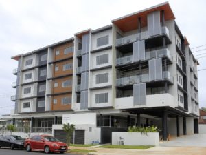
Apartments at 12-14 Wharf Street, Cleveland
At their previous meeting on 25 August councillors adopted a Multiple Dwelling Design Guide which “seeks to complement the City Plan by identifying the critical design elements which contribute positively to the creation of attractive and liveable urban spaces reflective of Redland’s character identity and lifestyle”.
The design guide attracted two submissions and two survey responses when it was put out in draft form for public consultation.
The document includes photos of many recently completed apartment blocks in Redlands which are considered by council officers to demonstrate desirable design features for apartment blocks.
One of the buildings featured in Council’s design guide is a block of 35 apartments at 12-14 Wharf Street in Cleveland. This building, completed more than a year ago, has attracted community interest for being apparently unoccupied with no obvious signs of any marketing campaign.
Koala report was controversial, sort of

A pastel drawing of Toondah koala Airlie is first prize in the Threatened Species raffle being conducted by Redlands2030
Councillors noted a report on actions planned for the Koala Conservation Action Plan. A motion to note the report was passed by a majority of 8/2 with Councillors Talty and Gleeson voting against the motion. The report by Council officers offered a positive outlook for the future of koalas in urban areas of the Redlands provided that appropriate actions are taken to conserve them:
Despite the pressures of urbanisation, the Redlands Coast has above average area of occupied koala habitat and has maintained at least three generations of koalas across the City. Redland’s koala population appears to still be ecologically functional, even in the predominately urbanised areas.
These findings are important as it provides Redlands Coast a window of opportunity to maintain current koala population levels. As such, it is imperative that the remaining population remains ecologically functional and not be allowed to dip below a critical threshold.
Council’s actions this year will include a pilot project to create a koala safe neighbourhood in Ormiston.
The Ormiston pilot project and other koala strategy actions are discussed in a Bulletin report.
Council’s discussion of koalas can be viewed on the meeting video recording, commencing at 1 hour and 16 minutes.
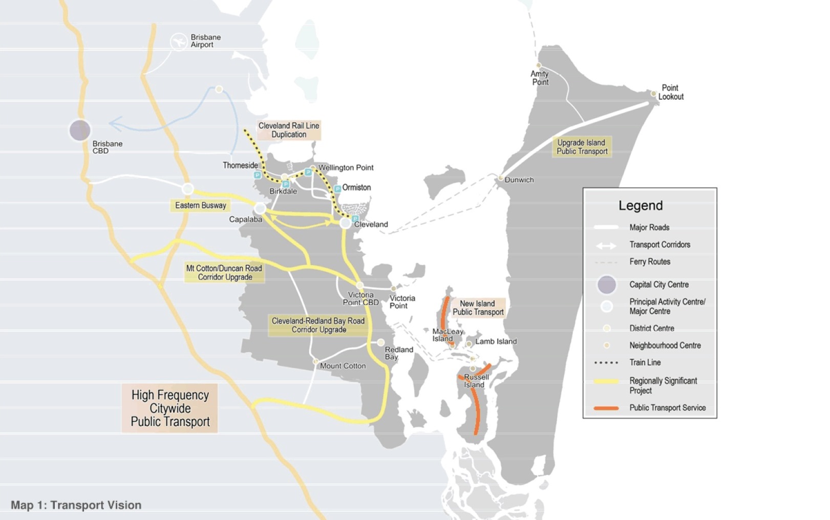
Redlands Coast Transport Strategy

Mayor Karen Williams election promise in March 2016
Redlands residents concerned about inadequate transport infrastructure will get little comfort from a Redlands Coast Transport Strategy put forward to replace the Council’s previous transport plan which expired in 2016.
The document does not appear to be tightly integrated with land use planning in the Redlands and does little to inspire confidence that much will actually happen.
Residents of the southern Moreton Bay Islands will not find any indications that anyone is thinking about building any bridges to the islands in the near, medium or long term.
The strategy suggests that Council should focus on advocating the following transport projects to be delivered, funded by other levels of government:
- Cleveland Rail duplication
- Eastern Busway, to Capalaba
- Capalaba road network upgrade
- High frequency public transport
- Public transport on the southern Moreton Bay islands.
Rising sea levels and storm hazard mapping
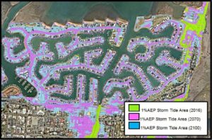
Map showing the difference between statutory mapping and the 2070 mapping
Maps showing expected impact of sea level rises by 2070 have been prepared by the Council for community information purposes. Maps cover both mainland and island areas of Redland City.
This mapping assumes a 0.41m rise in the mean sea level by the year 2070.
These maps are not intended to replace the statutory mapping required by the state government which assumes a 0.8m sea level rise by 2100.
In both 2070 and 2100 scenarios, roads on the canal estates are shown as being subject to inundation.
Is Council going to commit to providing all weather access to the canal properties in the future and what is Council planning to do to protect essential services e.g. sewers in these situations?
Birkdale Commonwealth lands
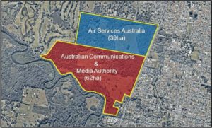
Birkdale Commonwealth lands
A petition presented to Council in June called for establishment of a community reference group (CRG) to assist Council to plan for the future use of the Commonwealth land at Birkdale.
Officers have now prepared a report responding to the petition and it will be discussed at Council’s meeting on Wednesday. The report says:
Until Council recommences land use investigations of the site, it is too early to determine whether
or not the establishment of a CRG should be part of the supporting community and stakeholder
engagement program.
The officers report notes that in May 2018 Council decided that its current intention for the land is ‘that it should be retained for community use, such as educational facilities and recreation, to protect the property’s environmental overlays and
significance’.
Education and Training strategy
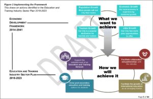
Education and training strategy
An Education and Training Industry Sector Plan strategy to be discussed by Councillors suggests the following:
- Foster collaboration and strategic partnerships
- Grow higher education and alternative learning pathways and support emerging industries
- Grow International education
The report suggests investigation of a Centre of Excellence for the Aging.
The report does not comment on potential use of the Commonwealth lands for education facilities but it does note that a city needs a population of about 500,000 for a stand alone university to be viable.
Redlands2030 – 4 September 2018
Please note: Offensive or off-topic comments will be deleted. If offended by any published comment please email thereporter@redlands2030.net
One Comment
Bridges to the Southern Moreton Bay Islands have never been and will never be financially viable. Bridges would need massive subsidies from the Government, money better spent elsewhere. Bridges were costed in the 2011 study by GHD, consultants to Redland City Council tasked with assessing bridge and alternative barge and ferry route feasibilities. A bridge between Rocky Point on Russell Island and Little Rocky Point on the mainland was estimated to cost about $113 million, at 2011 prices. And this was without examining the costs of needing to improve the roads on the mainland to accommodate the traffic or the environmental impacts and other potential policy conflicts. A bridge costing $113 million would need annual revenue of about $8.5 million to repay the loan and maintain the bridge, at government borrowing rates. Private sector funding would cost much more. Do the sums. For example, if Russell Islanders made 85,000 return trips per year, the toll would be $100 per trip. Consider also that one end of the bridge would be on Gold Coast City property, not Redland City property. The Gold Coast City Council is not interested.