What’s a view worth? The scenery and beauty of Redland City is often mentioned by the Council but its Draft City Plan does nothing to protect our best views.
We need a planning tool to ensure that our scenic amenity is protected and managed. The good news is that there are ways of doing this.
Scenery is prized in the Redlands

Scenic Preference of 10.0 -the highest rating view in SEQ is that taken over The Gorge in Redlands
The Draft City Plan claims that it:
supports the community’s vision of a well-designed, vibrant city renowned for its natural, scenic and cultural values, its robust local economy and its active, resilient and connected community.
There is room to reject or quibble about many aspects of the draft Plan but nearly all Redlanders will agree with the emphasis placed on the natural attractiveness of the City. The images of our natural and rural landscapes, the waterways of Moreton Bay and beaches of “Straddie” are the images that residents and visitors alike associate with “the Redlands”.
A photograph of “The Gorge” at North Stradbroke Island was found to be the highest rated view in south east Queensland (SEQ) in a recent study of scenic amenity.
Benefits of Scenic Amenity
Social benefits of scenic amenity
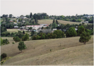
Rural landscapes rate higher than some people expect: this scene was rated 7.2
It is well known that encounters with nature help alleviate mental fatigue and can speed recovery from illness or surgery. Parks and green spaces are settings for cognitive respite, encouraging social interaction and de-stressing through exercise or conversation.
It seems that “visual access” and being within green space helps to restore the mind’s ability to focus. This can improve job and school performance, and help alleviate mental stress and illness.
So if you think it looks good, it probably is good – for you.
Economic benefits of scenic amenity

Urban development rates poorly …this view was rated 2.9
The scenic values of the Redlands such as “beaches and the bush” are prominent in all forms of advertising and tourism promotions including Council’s:
- Redlands Open for Business and Investment and
- Redland City Tourism Strategy and Action Plan 2015 – 2020
Recent research has clarified the value of scenic amenity for residents of South East Queensland. Using a 10-point scale, on average, south east Queensland respondents will pay approximately AUD$14,000 in household income per year to get a one-point improvement in scenic amenity. However, the relationship is non-linear and better quality views have a premium value. So scenery has real economic value for those who enjoy it.
It’s a no brainer…people pay a premium for views.
Community benefits of scenic amenity
(click to enlarge)
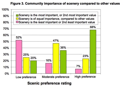
In some circumstances, people consider scenic values to be more important than nature conservation.
Public preference surveys show that 68 per cent of people consider scenic values to be the most important or second-most important values at places where the scenery is highly preferred. The results of the opinion survey showed that preferred scenery involves views from lookouts over the ocean, beaches, rocky cliffs, bushland, rivers and mountains.
These results confirm that the “man in the street” understands the importance of scenic amenity and the need for regional and local planning to protect high scenic amenity areas, significant viewpoints and important view corridors.
Mapping scenic amenity
The term “scenic amenity” was developed for use in regional planning in SEQ. it is now a well recognised landscape value, defined as:
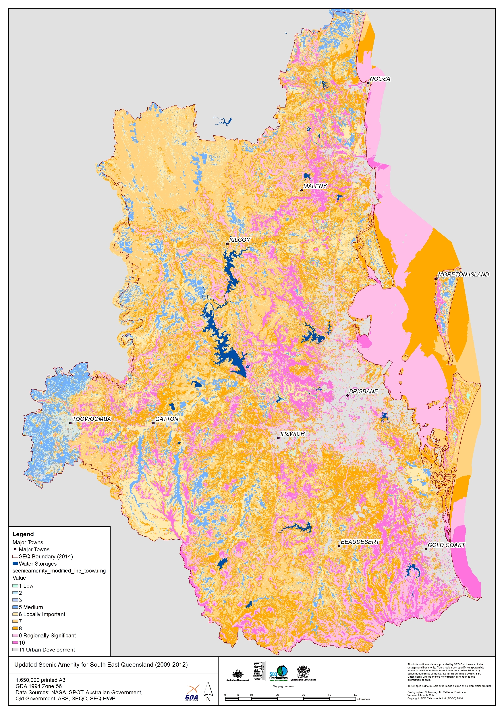
Scenic Amenity Mapping for SE Queensland is readily adapted for Redlands City and the City Plan 2015 (click to enlarge)
“a measure of the relative contribution of each place in the landscape to the collective appreciation of open space as viewed from places that are important to the public” .
The SEQ Regional Scenic Amenity Study provides a guideline by which Councils can manage scenic amenity at a local government level: Implementation Guideline No 8—Identifying and protecting scenic amenity values
The scenic amenity rating (measured 1-10 scale) is calculated by combining the independent factors of:
- Scenic preference, indicates the relative preference for different landscape features. Features such as the ocean have a high scenic preference, while features such refuse depots have a low scenic preference. The score of particular images views was measured from structured community workshops and the results showed repeatability across different population cohorts. The “views of people about scenery are remarkably consistent. The photographs attached to this story were taken from the SEQ study and the scores are as derived from images taken from across SEQ.
- Visual exposure, indicates the relative visibility of mapped landscape elements from public viewing locations. Landscape units such as hillsides facing towards a city, that are frequently seen by many people, have a relatively high visual exposure. Places rarely seen, such as remote hidden valleys, have a relatively low visual exposure.
The SEQ methodology (which received a Merit Citation from the Planning Institute of Australia National Awards for Excellence) can be readily scaled and adapted for use in the Redlands.
Protecting areas with high scenic amenity
The Guideline No 8 proposed that local governments may develop strategies to protect a seen landscape area from developments that diminish high scenic amenity.

Canal development: moderate rating of 5.9
It was suggested that a local government may seek to protect the values of the area by either:
- introducing planning controls to define what is ‘acceptable’ development of the area or
- adopting other defined measures to achieve similar outcomes.
The rating of photographs can be used to estimate the scenic amenity impact of development. The existing rating of the landscape could be used as a planning overlay. Measures of a view are much more robust than the opinion of a proponent, a Councillor or an assessment officer.
Why no scenic amenity map in City Plan 2015?
Clearly, the protection of the scenic assets of the Redlands for the enjoyment of current and future generations accords with the community vision and the strategic intent of the Draft City Plan.
The lack of a scenic amenity overlay seems an obvious oversight in the Draft City Plan. Scenic amenity values are one area of planning where community opinion is fairly unified and a planning layer could be developed. If the City is going to talk about views in its tourism brochures, it should protect them in its City Plan.

View from the Gorge Walk at North Stradbroke Island
Redlands2030 – 7 November
Please note: Offensive or off-topic comments will be deleted. If offended by any published comment please email thereporter@redlands2030.net
2 Comments
I recall Redlands was at the forefront of the SEQ project. I took some photos and there were people from all over involved in taking photographs and I think there many more involved in the trying to score the photos. It was a really good process and it brought people together. Why wouldn’t Council use the information as a layer of whatever in the City Plan, especially as the draft Plan puts so much emphasis on how Redlanders and visitors like what they see when they get here.
Surely its not too much to ask for Council to give an explanation…but I suspect they will say “make a submission”…How can we make a submission on something that isn’t even there?
‘Everybody needs beauty as well as bread, places to play in and pray in, where Nature may heal and cheer and give strength to body and soul alike.’ John Muir, 1912. Muir spearheaded the national parks movement in the USA, a magnificent idea quickly adopted here in Australia. A hundred years later we have arguably greater need of the healing and cheering benefits of natural places and views. Yet – incredibly – in the Redlands we have to justify the preciousness of irreplaceable coastline views and plead to retain scraps of land where wildlife and residents find solace. Redland Council fails to see their value! At Point Lookout, it imposes incongruous mainland-style road standards, lighting, signage and civic landscaping on the Headland – overlooking one of the most wonderful ocean views in Australia. Stuff the natural context, stuff the exhilarating sense of standing at the very brink, of being on an island. Although the rugged grandeur of parts of the once-mighty Gorge Walk may still be glimpsed, the wild, natural experience of the entire walk is now tamed and mediated by a crass timber-caged walkway: the Council did not know another way to make a safe path. They don’t get it.
Given the mind-set of this Council, it is perhaps no wonder there is no Scenic Amenity map in the 2015 Draft City Plan. But this absence is unacceptable. Scenic amenity must be identified, valued and protected in the Plan. John Muir’s battles for the benefits of natural beauty must be fought all over again.