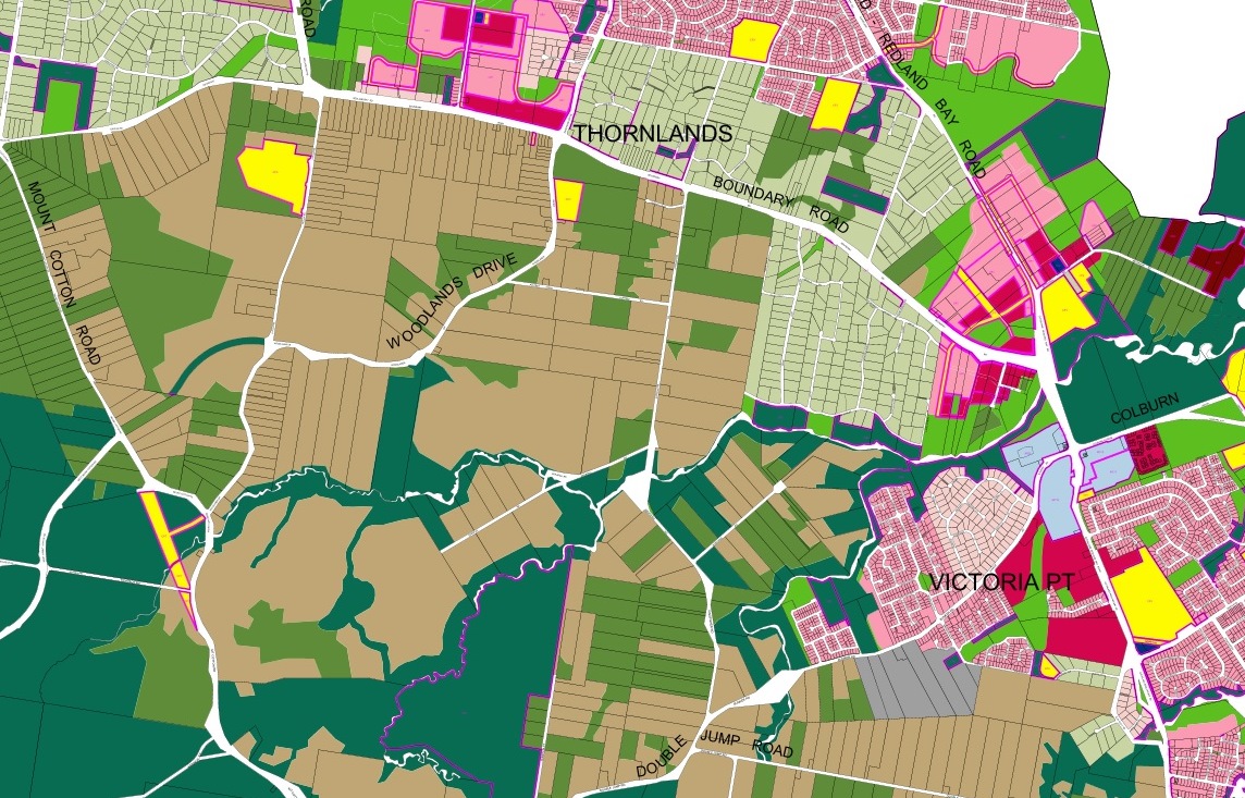
Thornlands area in the current Redland City Planning Scheme (click to enlarge)
When is a city planning scheme not important?
When its the Redland City planning scheme and well connected developers want to do projects that are not included in the designated urban footprint, apparently.
Woodlands Drive and Taylor Road in Thornlands
On 21 October the Redland City Bulletin reported on a Council decision, at a Special Meeting on 16 October, about a development application for a 332-lot sub-division on the corner of Woodlands Drive and Taylor Road. This application was rejected by Council in 2009 on the basis of an officer’s report which said the development was “contrary to orderly, efficient and sustainable planning” and was “premature” and not supported by suitable infrastructure.
The developer appealed and until now Council has been defending its decision in the Planning and Environment Court. It seems that the pro-development councillors may have just decided to roll over and let this development proceed despite the lack of fit with the City’s planning scheme.
The minutes of the Council meeting on 8 October (Item 16.2.1) show that Mayor Williams had a conflict of interest on this matter because the developers “attended a couple of fund raising events”. This conflict did not cause the Mayor to leave the chamber during the debate on this matter but the record shows that she left the chamber before the vote was taken.
Shoreline
On 17 October the Shoreline project advertised for public comment on its development application which proposes to subdivide a large area of southern Redlands into 4,000 new homes in an area outside the City’s Urban Footprint.
Why has Council granted Shoreline an enormous discount on its assessment fees when it is proposing a development that it is contrary to the current planning scheme and outside the Urban Footprint?
Shoreline’s development application number is MCU013287 .
The Urban Footprint
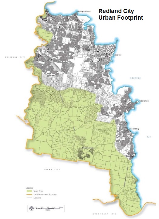
Redland City Urban Footprint (click to enlarge)
Redland City’s urban footprint was clearly established in the South East Queensland Regional Plan 2009- 2031. While environmental considerations played a part in this, a more compelling reason for the shape of the urban footprint is the need to focus urban settlement on areas well served with established infrastructure.
When the Local Government Reform Commission reviewed city boundaries its report recommended that Redland City remain a separate local government authority in part because of the large non-urban area separating Redland City from Logan City and Brisbane. So the large non-urban area around Redland City helps to define its reason for being a separate city rather than a suburb of Brisbane or Logan City.
The Urbis Report
URBIS Australia was engaged by the Redland City Council to advise if the City has enough land for future development.
Their report dated August 2014 notes that there is:
• Significant oversupply of land (particularly on the islands) for detached residential dwellings; and
• A potential undersupply of land for attached residential dwellings in the long term.
To cater for the potential long term undersupply of attached dwellings, the report recommends a number of options, including:
- Incentivise the reconfiguration of urban residential lots where capacity exists to increase dwelling yield from these lots. This could be facilitated through reduced minimum lot sizes and relaxations on infrastructure charges. Also a fast track planning approval process could be set up.
- Convert appropriate areas of Low Density Residential land to Urban Residential land. This will thus increase the dwelling yield from the existing land supply. Investigations will be required to identify the scale, location, and timing of any rezoning.
- Extend the Urban Footprint to bring new land suitable for residential development into the Footprint. In this regard investigation areas have already been identified that may be appropriate for this. This will require further investigations on which areas are most suitable in this regard. We recommend that analysis be undertaken on this land to determine government development costs and timings. We also recommend that an assessment be made on the scale and location of new Urban Residential land to be added to the Redland City Council land supply based on government costs, optimising development yields, and timing requirements. (editor – bold added)
Forecasting

Does Redland City use this sort of forecasting technique?
One of the limitations of long range forecasting (such as 27 years to 2041) is that things change (often dramatically). Typically, land supply projections for Councils and developers are 10 – 15 years, with longer projections subject to wider margins of error and change. This report does not do that.
Supply of land and housing is relatively static as they exist and are able to be counted. Areas of land zoned for urban, numbers of subdivision allotments, etc, can all be counted. Demand, especially market demand, is more elusive and fickle. For example, the market acceptability of higher density living in Brisbane has changed dramatically in recent years. Teneriffe, Newstead and Woolloongabba are good examples of targeted areas for higher density in Brisbane, showing there is now a greater acceptance and indeed healthy appetite for higher density living.
Urbis did not (and probably were not asked to) consider the community goals and aspirations as documented in the Redland’s 2030 Community Plan. Land supply calculations and projections are only one tool in developing a future plan for the Redlands. So, let’s look at planning for future growth in the Redlands in perspective.
Planning in Context (or how planning for communities really works)
It is probably fair to say that higher density housing has not been on the development radar or particularly popular with potential owners in Redlands. However, as the region’s population ages, then higher density and smaller living units will likely be more acceptable as people’s desire to remain in the Redlands drives housing choice.
Already we have seen the State Government setting targets for higher density living across SEQ, and acknowledging in The Queensland Plan that the people (not the politicians or the planning technocrats) have said they want future growth to “go up, rather than out”.
The Urbis report does not consider these likely policy / demographic trends except to dismiss the Qld Treasury’s population and dwelling unit targets (Scenario 1) as unachievable, and to propose alternative lower targets (Scenario 2) – without any statistical rationale. The State Government has provided these targets to Councils in SEQ since 2005 in the SEQ Regional Plans. But apparently they are now wrong.
The Urbis report does not deal adequately with land take up and the timing of the “demand” (or otherwise) for residential land. Population growth in the Redlands is relatively slow; approximately 1.2 % per annum. Recent take up rates of land for residential purposes has been similarly slow. As additional land is required in the future to cater for population growth and residential housing, the demand is so slow that the existing land zoned for residential purposes would be adequate till 2035, at least. That’s 20 years, or more. A lot can happen in a volatile housing market over 20 years.
So, why does this report even consider the expansion of the Urban Footprint, particularly as the supposed shortfall is in detached dwellings ? A smarter planning and more cost effective response would be to target existing centres of Cleveland, Capalaba, Alexandria Hills, Wellington Point and Victoria Point for higher density and renewal opportunities.
What Should We do About it ?
The community should demand that the touted investigations to extend the Urban Footprint are premature, and unnecessary. The report is highly qualified and does not present a compelling case for urban expansion.
In planning for Redland’s future growth, Council must accept that:
- there is an existing urban land supply for attached and detached housing till 2035 and beyond. There is no current demand for additional land releases or to expand the Urban Footprint for at least 20 years
- there is greater demand for targeted higher density living choices at Redland’s existing centres
- the State Government’s policy directions (The Queensland Plan) towards higher density living and less demand for growth in SEQ prompt a critical (or peer) review of the Land Supply Analysis. The assumptions in the Urbis Report have been superceded by the Qld Plan, and are now wrong
- the real impacts of urban sprawl on lifestyle, livability and financial legacies for Redlanders must be considered in the broader planning decisions to be made. No single technical assessment tool should be used as an excuse to promote urban sprawl or as a surrogate for planning for communities
- The community aspirations in the Redland City Council 2030 Community Plan 2010 are fundamental to future planning in Redlands.
City Plan 2015
The council is still finalising a draft new planning scheme for Redland City. It will be known as City Plan 2015. This document will need considerable review by the City’s residents to ensure that the document has been drafted to serve the public interest, not just the interests of property developers.
To facilitate such review the council should make the draft plan available to the public at the same time that it is submitted to the State Government for review. This process has already been followed by some cities including Brisbane. Council should also confirm that it will allow a period of formal public consultation that is not less than 60 business days (about three months).
Please note: Offensive or off-topic comments will be deleted. If offended by any published comment please email thereporter@redlands2030.net
If the Council is going to support developments outside the Urban Footprint, then what is the use of having one! Our rates are already among the highest in the region. The Council should be protecting the ratepayers from unnecessary costs. Any developments outside the planned infrastructure should bear the entire costs not only of the infrastructure within the development, but associated costs of water, sewerage, drainage, roads from the approved urban area.
How can the public have enough influence on the council to ensure they will be listened to. They only note down what suits them, always have.and always will. The public can never know what goes on behind closed doors at closed meetings. It should have been obvious before the election that this would be a pro development council are people so blind or don’t they think..
You say Council has “granted Shoreline an enormous discount on its assessment fees” .
Can you give more detail on this please?
Any slug for ratepayers is not welcome.
There was a time when the developers who lodged an application that was non complying with the planning scheme paid double the council fees and charges as the amount of work staff had to do to assess the application increased. Then ex Mayor Seccombe and the Seccombe six changed the rules and allowed developers to lodge non complying plans yet paid the same fees as those who complied. Interesting there were developers who had assisted in the previous election and who were lodging these types of plans at the time, Ausbuild in Bunker Road as one example.
We recently heard that Shoreline has received a substantial discount in Councils recommended fees and changes, this money is calculated on the time taken to assess applications Shoreline is non compliant so I assume the extra staff costs for the assessment is coming from the ratepayers. Oh to be in favour, it helps when these companies gave a variety of support to Mayor Williams and her team.
Thank you Redlands 2030 for this post. Clarification of so many matters at the moment is important and there is so much in this item to study and digest.
My first question: If officers considered a development application in the Woodlands Drive Taylor Rd at Thornlands was “contrary to orderly, efficient and sustainable planning” and was “premature” and not supported by suitable infrastructure, then why has that not applied to Shoreline? Surely officers would be pointing out the same in 2014 as back in 2009? Or do Councillors now make the plannings grounds as they go at meetings many of which are behind closed doors ?
I am reminded that in the past Council had Engineers whose word was law: the then Shire had facilities up to certain boundaries and nothing went beyond.
The difference is that Woodlands Dvd/Taylor Road development lodged their plans and they were assessed and came to Council for a decision, council officers refused the developerment and Council supported the staff decision. In Shoreline case they have only logged their application it hasn’t been assessed and no report has come to council with an officers recommendation and Councillors have not made their decision. This is my assumption, but I am out of Redlands at the moment, so not sure if things have progressed. Would think it will take a long time to process the application for Shoreline, or maybe it will be just a tick and flick. Sadly it is so convenient to buy large parcels of rural land at a cheap price then look after those in power and get an approval for thousands of homes
Very relevent comments. An issue not covered is the way of dealing with small infill sites that are in the midst of existing detached residential areas. Any developemnt on this sites must not be intrusive or out of charater with the existing neighbourhood. seems to being ignored .
I am Impressed with the comments in the post, hope b that the Council this time has a more inclusive public consultation process. The maximum of 20 people at three venues for one hour was a disgrace, encourage people to attend meetings at their local halls, on Saturday or nights, don’t exclude anyone, promote the meetings, give as many people as possible the chance to have their say, and tell the community, this is what the Concil wants what do you want, as people don’t realise that once it gets the TICK that’s it. No change or there is compensation to the developers from the public purse. So the residents must be proactive.
The development proposed will be south of Redland Bay and Wodlands Drive/Taylor, Springacre Road both areas that were very vocal during the 2012 election, both areas had residents who were also giving a range of support to Mayor Williams and her team, just have to see how many times the Mayor has a conflict of interest, but her team should also annouce their conflict as they benefited from these same groups during the election period.