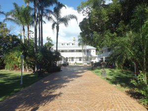
Whepstead is one of Redland City’s historic homes
I am sitting here at my office window in Whepstead (Manor) precinct, Wellington Point, listening to the industrial thrum of my neighbour’s air conditioner, a recent addition to this home. I had been wondering about the pros and cons of infill housing for some time and decided I should write a critique of this style of development as our City Plan is up for review.
Infill housing is rapidly happening throughout our area as it is close to the train station. It is part of the process of urban consolidation to increase housing and hence population density, typically around transport nodes, either through small lot subdivision and/or units/townhouses.
So in this series of articles, I want to examine the goals of urban consolidation and some reviews of this type of development. Then through my own observations and experience of living in the Whepstead precinct, critique some aspects of urban consolidation regarding sustainability goals and liveability.
The goals of urban consolidation
The original goal was to maximise the use of infrastructure such as rail, water and electricity systems in established areas where population density had decreased in the 1970-80s with smaller families and the move to the ‘outer burbs’. In some cases, governments also wanted to address declining enrolments at older schools and in other cases maintain the electoral composition to enhance re-election chances.
In the 1990s this was broadened to include sustainability goals. These included slowing or halting urban sprawl and hence saving rural and bush lands for agricultural or other purposes. It aimed to improve energy efficiency and reduce greenhouse gas emissions by better urban and building design and access to public transport. This included mixing residential and commercial areas to provide work closer to home. Often a mix of housing styles (detached/units/townhouses), size and affordability were provided to meet government social goals such as equity and access to services and work (Troy, 1996).
As a sustainable energy systems engineer/educator and environmentalist, I see these sustainability goals as laudable because our current infinite growth economic model is clearly at odds with a finite planet. We are currently consuming unsustainably the resources of about 1.5 planet Earths (Global Footprint Network, 2010:18). Our ecological footprint (a measure of the area of land and water required to support each of us) is about 6.8ha per person, 5 times the global sustainable, fair share (Global Footprint Network, 2010:19). This should be a great concern to all of us. Humanity is in what is called ‘’overshoot” mode by environmental scientists, living beyond our means on a planetary scale and eating away our natural capital on which all life depends (Rockstrom et al: 2009).
Perils of Urban Consolidation
A major critic of urban consolidation, Patrick Troy, outlined key criticisms in his 1996 book, “The Perils of Urban Consolidation”. These included flaws in the analysis of data underpinning consolidation policy such as occupancy rates and dwelling size, and infrastructure savings were overstated and may be offset by other costs and loss of amenity. Furthermore, environmental outcomes are unlikely to be achieved. For example, unless the public transport is clean, efficient and timely, car numbers can increase, with increasing air and noise pollution; it is harder to recycle organic wastes on site with increased housing density. There is limited space for rain or grey water storage unless underground, and the increase in hard surfaces creates more run-off and flooding potential. As well, Troy points out that restricting urban sprawl ultimately depends on addressing population size and growth, goals which are clearly at odds with current, endless growth centred, economic policy.
Glen Searle, a planning academic from the University of Sydney, outlined the concerns of Sydney residents in older suburbs where urban consolidation started in the 1980s. He states:
Local communities were concerned that consolidation would generate a variety of local spill-overs, including loss of green environment, extra traffic, loss of privacy, and loss of streetscape quality. The latter concern arose to a large extent from the experiences of the 1960s, when re-zonings to allow higher densities resulted in older houses being demolished for three storey flats. These had no landscaping, they overlooked neighbouring house yards and windows, and their plain block forms ignored prevailing local architectural forms.
Many of these concerns are evident still and were expressed in the Redlands 2030 Community Plan consultation reference group workshops that I was involved in. Many concerns revolve around the “liveability” of an area. This is a term that has many possible meanings? In general it includes measures of quality of life, social cohesion, access to services, and sporting and cultural engagement.
There is substantial debate around the benefits and disadvantages of urban consolidation in terms of liveability. Recent research by CSIRO’s Rod McCrea and University of Queensland academic, Peter Walters, concluded that residents in Wynnum, a bayside suburb of similar density to Wellington Point, were concerned about overcrowding, increasing traffic and parking and social problems. Planning experts theorise that there is an optimum level of population density where the added benefits of access to additional services for example are not outweighed by the negative aspects mentioned by residents as they see the impact of urban consolidation on their quality of life.
The Whepstead Precinct Context
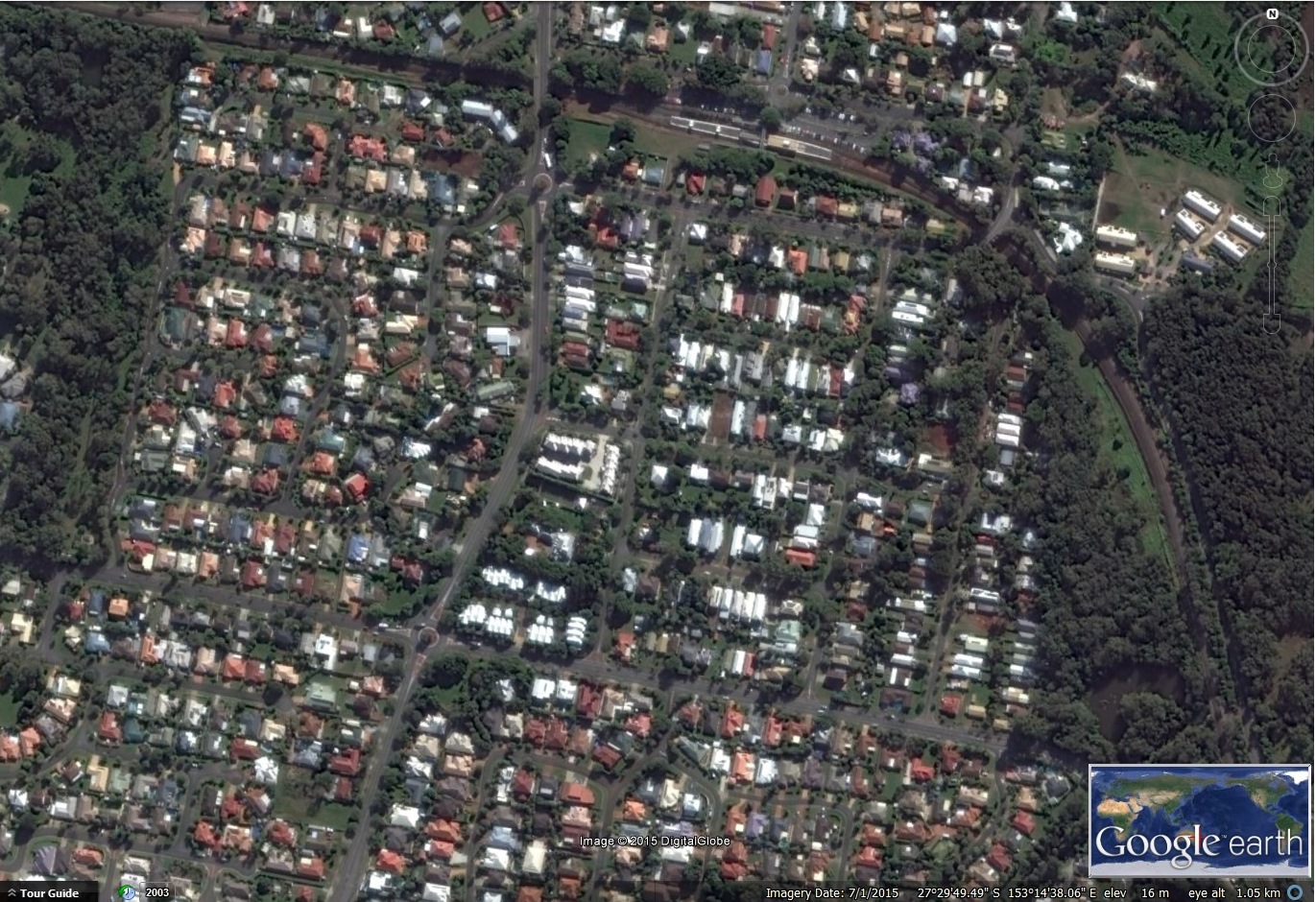
Aerial Photograph of Whepstead Precinct and neighbouring Modern Precinct to West of Main Road (click to enlarge)
The area that I live in is Burnett Street, in which the historical home, Whepstead Manor (circa 1889) was built. The Whepstead precinct was part of the original European settlement centre of Wellington Point.
Initially developed around Fernbourne Road, Station and Harris Streets in 1885, it was later extended around Whepstead Manor in Burnett Street, named after the developer, Gilbert Burnett (Howells, 2000). The Wellington Point village centre has how moved further north. This subdivision was typical of its time, with wide open streets running north-south and east-west, and open spoon drains with grassy verges. These were the days of the horse and buggy.
A mix of housing occurred over time, with most homes spread over two blocks of about 400m2 each. The area was very leafy, with many large trees including gums, silky oaks, mangos and jacaranda. The largish block size and relatively small house size meant there was plenty of outdoor space for either trees, gardens or playing areas. There are no parks of any significant size in the area. It is bounded to the north by the railway line, to the east by Hilliards Creek and Geoff Skinner wetlands reserve, to the west by Main Road and south by Duncan Street.
This design contrasts markedly with modern subdivisions where developers are required to provide open green space and often a wetland area to capture and slow run-off, but houses are crammed into small lots, often with very large houses. Australia now has the dubious honour of the largest average detached house size globally (ABC, 2011). As well, modern estates tend to have curvier, narrower streets, with lots of cul de sacs. This design aims partly to slow traffic and to limit “rat running”.
The aerial photograph shows both Whepstead Precinct and a more recent development to the west. On the right side of Main Road you can see the more rectangular layout of Whepstead Precinct. There are still plenty of trees in areas to the east and south that are not yet densely covered in housing. This contrasts with the design to the west on Main Road with fewer trees and cul de sacs.
A summary of the outcomes of urban consolidation in Sydney up to about 2007 is given below by planning academic, Glen Searle.
Housing affordability was improved in early phases when three-storey apartments dominated the program. But subsequent emphases on town houses and then on high rise apartments in inner areas have usually resulted in prices higher than the average Sydney dwelling price, or else sacrificed good urban design for affordability. Outer area consolidation has sacrificed accessibility for price savings. Infrastructure savings in hydraulic services (water/sewerage) have been offset by greater pressure on limited road capacity from extra traffic. The advantages of the back yard have not been compensated by increased per capita provision of open space in consolidation areas.
Whepstead Precinct had an ambience that is quickly being transformed. Those of us who have lived here for 10 years or more are witnessing this transformation with some concern. Are the Sydney outcomes to be the destiny of Whepstead Precinct?
Written Trevor Berrill November 2015.
Trevor Berrill has written a series of three articles to be published by Redlands2030 over the next few weeks.
Editors note: infill housing and the Draft City Plan
City Plan 2015 has embraced urban consolidation in a way that will impact across the City. But the rationale for this form of development and its likely consequences have not been discussed with the Redlands community.
The City Plan approach is being seen, more and more, as faith based planning rather than evidence based planning. The consequences are being imposed on a largely unsuspecting community.
It is not too late to make a submission on the Draft City Plan.
Please note: Offensive or off-topic comments will be deleted. If offended by any published comment please email thereporter@redlands2030.net
3 Comments
Thank you Trevor.
Yes Redlanders are fast losing the ambience they treasure.
How will a new Council protect this value we love?
After yesterday when Mayor Williams, deputy mayor Alan Beard, head of planning Cr Talty and Crs Hardman, Edwards and Gleeson voted for trucked sewerage, midge screening on windows plus lots of other goodies all dependent on 300 or 1000 or 3000 blocks being built on, then what have we got to worry about?
I’m speaking of the above named six that think they know what is best.
Over to a new Mayor please.
It seems to me that Redlands, a leafy outer shire in SE Queensland, and the smallest local government area, is acquiring the housing imprint of inner city areas at least 30 or 40 years before anyone would expect them to appear – cluster homes, townhouses, units, even in areas not close to transport hubs.
All this without the attendant improvements to arterial infrastructure – in other words no improvement or increase in train services, no main road upgrades or new roads to cope with the massive increase in housing.
A huge increase in home building in Redlands can only result in the dropping of house and land values as more brick and tile monstrosities become available. There are not queues of 40,000 or 50,000 people waiting at Redlands borders, desperate to live here. The drift to Redlands over the last fifty years has been just that – a drift, not a tsunami.
Faith based planning!
These are the words I was looking for.
The yummy new Shoreline now approved doesn’t even have sewerage it seems but will rely for some time on ‘tankering’ probably to Mt Cotton according to officer speaking in Council.
Isn’t that what one sees in Dubai with convoys of tankers heading to the desert?
There’s a flash housing estate near Bucharest with new shiny houses that is not even connected to sewerage..
Yes, faith based planning !
We are such a smart city for thinking of it.