
Update 22 June 2015
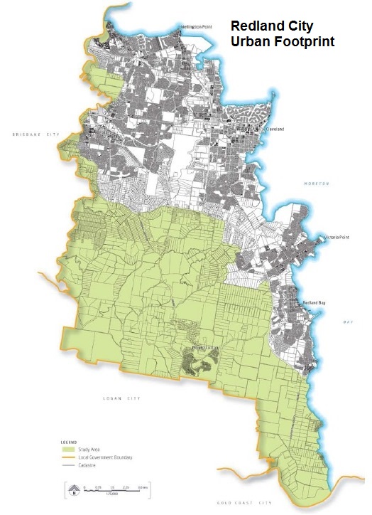
Redland City Urban Footprint (click to enlarge)
This article was originally published in September 2014. It discusses the Redlands Land Supply Review 2014, prepared by Urbis for Redland City Council as an input to development of the City Plan 2015.
The Urbis Report was publicly released in August 2014 although it had been made available to the Developer Industry Reference Group (DIRG) as early as May 2014.
The Urbis Report found that Redland City has enough land supply to meet expected population growth to 2041. The report noted the possibility that, based on current preferences, by 2041 there may be an oversupply of land for attached dwellings (e.g. apartments and townhouses) and an undersupply of land for detached dwellings (houses).
Urbis recommended (Section 4.2 of the Report) that a number of options be investigated to increase the supply of residential land for detached dwelling development, including:
- Incentivise the reconfiguration of urban residential lots where capacity exists to increase dwelling yield from these lots. This could be facilitated through reduced minimum lot sizes and relaxations on infrastructure charges. Also a fast track planning approval process could be set up.
- Convert appropriate areas of Low Density Residential land to Urban Residential land. This will thus increase the dwelling yield from the existing land supply. Investigations will be required to identify the scale, location, and timing of any rezoning.
- Extend the Urban Footprint to bring new land suitable for residential development into the Footprint. In this regard investigation areas have already been identified that may be appropriate for this. This will require further investigations on which areas are most suitable in this regard. We recommend that analysis be undertaken on this land to determine government development costs and timings. We also recommend that an assessment be made on the scale and location of new Urban Residential land to be added to the Redland City Council land supply based on government costs, optimising development yields, and timing requirements.
Recently, the new Labor Government has given a qualified green light to massive residential development at Toondah Harbour. The availability of this additional accommodation (likely to be mostly attached dwellings) was not factored into the land supply forecasts made by Urbis.
The appropriate time and place for examining and resolving the question of long term land supply requirements is through a fully informed review of Redland City’s planning scheme – City Plan 2015. This point was made in the post: Does Redland City need Shoreline?
Redlands has enough urban land for 25 years

Be careful with planning assumptions
Does Redland City have enough land for building new dwellings over the next 25 years?
This is a key question to be addressed by the new planning scheme known as City Plan 2015.
Redland City currently has areas of land that are zoned for development of houses and units within a geographical area known as the “urban footprint”.
URBIS Australia was engaged by the Council to advise if the City has enough land for future development. Their report paints a picture of adequate supply of land for development within Redland City’s urban footprint. There is no justification in this report for any immediate action by the Council to allow any expansion of Redland City’s urban footprint.
Urbis is a consultancy firm providing a wide range of land use, planning and urban development services.
Land Supply assumptions
The assumptions that underpin a long term forecasting exercise can have a significant influence on the report findings. Assumptions made about population growth and accommodation preferences (houses or units) will determine if the City’s existing urban footprint is big enough for development up to the year 2041.
It is regrettable that the Redland City Council did not commence the City Plan 2015 process by consulting the community about these key planning assumptions.
Land Supply: Context and Housing Trends
In this report Urbis updates a land supply study that they did in 2012. The new report has a longer planning horizon out to the year 2041.
Overall, the new report seems robust but Urbis have been very clear about the limitations of the study. For example, they state that the numbers do not include Shoreline and other “land exclusions” as these are not “approved” development areas or likely to be developed. These are reasonable assumptions.

Plenty of room
Urbis noted that their analysis is based on the “medium” series of population and dwelling projections from the Queensland Treasury, with some significant qualifications. The review of demand notes a generally downward trend in projections in the Redlands and an overestimation of dwelling unit requirements.
The report also notes a significant over supply of land on North Stradbroke and Southern Moreton Bay Islands.
These trends are mirrored by the lack of interest in higher density dwellings in Redlands. It is understood that the National Institute of Economic and Industry Research (NIEIR) proposes a revised forecast for population and dwelling projections below the “low” series. This is due largely to assumed infrastructure limitations.
25 years of Land Supply

Redlands Land Availability
Urbis noted that the mainland has about 25 years of land supply for new dwellings (without Shoreline or any other “not approved” development). Queensland Treasury notes a balanced land supply and development take up rate with predicted higher rates of residential density, aligned to the requirements for other Council areas in SEQ.
The report appears to dismiss the Queensland Treasury projections in favour of a “guesstimate” rate of development up-take without any basis. This scenario magically results in identifying a shortfall for detached dwellings and the need for “further investigations” for the proposed Shoreline development.
Trend, Destiny and the Queensland Plan?
The analysis appears to expect a continuation of the traditional development pattern with detached dwellings on small to large blocks of land that cut into our rural and conservation areas. Urbis does not consider future changes in Council or State policy, or changing consumer preference for, higher residential densities as is the norm elsewhere in SEQ. Think of how many people in Redlands were living in high density housing 15 years ago, and think how many are now. That trend will increase, particularly for people as they grow older and don’t want to leave the Redlands.

The Queensland Plan
The analysis does not fully take into account the State Government’s policy direction for urban communities in the Queensland Plan which proposes:
- that future development “goes up rather than out” and
- “doubles the population of regions outside SEQ”.
For the next 15 years (at least) half the population growth in Queensland will be catered for in regional areas outside the SEQ region. If the population outside of SEQ doubles by 2041 that will take a lot of “heat” off residential demand in SEQ and dampen any requirement for an extra 80,000 people by 2041. This could mean up to a 50% reduction in the projected population growth of Redland City, and the subsequent demand for housing.
These overriding policy directives and the smart growth options require that the Urbis analysis should be re-assessed before consideration for input into the City Plan 2015 or for any major new development applications.
The SEQ Regional Plan
The South East Queensland (SEQ) Regional Plan is also under review at this time. Progress of this review is being held under-wraps by the State Government. But it is known the planning horizon for the Regional Plan is 2041.
Infrastructure Staging is Pivotal
Another thing lacking is discussion of staging for land supply and infrastructure. This is of concern given Council appears to be supporting a massive “out of centre” developments like Shoreline and the PDA’s.
The Council recently requested the State Government to include a bridge to Russell Island in the State Infrastructure Plan. If this bridge is built then thousands of housing blocks would then be added to the “available” land supply.
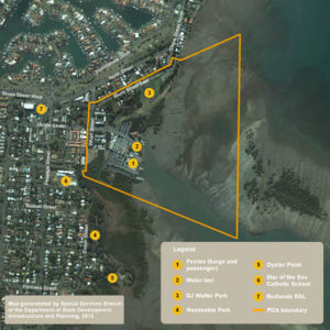
Toondah Harbour PDA area
There will be increasing infrastructure demands on the Redland ratepayer to upgrade or provide new infrastructure. Infrastructure costs of major urban development projects for Toondah Harbour PDA, Weinam Creek PDA and (the recently announced) “TOD” near Cleveland Railway Station are significant and need to be identified in any infrastructure planning model.
Further, it is unclear how these projects interact with each other, the CBD, other centres or whether there is indeed a master plan for how these projects will come together!
What is clear is that each will put enormous pressure on existing infrastructure and change the staging of roll out of infrastructure.
Do we really know what these costs to the community will be ?
The developer will not be paying for it all, regardless of what the Council keeps inferring and telling us.
Options exist for better use of the existing urban land supply. If there is an upsurge in housing demand, Urbis also notes that there are approximately 10,000 large lots in the exisiting Urban Residential category that could be subdivided in the future. This would be more than enough to cater for future demand for any housing.
Clearly, there is no strong development or planning argument for additional detached dwelling sites outside the existing urban footprint to be either proposed or favourably considered by Council.
A Smart Growth option?

Earlier this year the Council of Capital City Lord Mayors (CCCLM) released the report Unlocking Smart Growth in Australian Cities.This report was prepared by Urbis Australia.
Some of the findings of this report provide useful grounds for further review of the Land Supply report and the City Plan 2015. Among the findings was the assertion by the Lord Mayor of Melbourne that a “Smart Growth approach to increase populations in established areas means people living in those communities have easy access to jobs, a range of housing and transport choices and public spaces“. He went on to say “Building in established parts of a city is cheaper than building new developments on city fringes and therefore reduces the pressure on federal and state governments to provide the required infrastructure.”
The report presents a number of principles to guide smart growth in Australia cities, including:
- building only on the land we need and making the best use of existing and future infrastructure investments;
- creating connected places that are easy to move to and through;
- supporting resilient and adaptable communities that offer healthy lifestyles choices for current and future residents; and
- offering opportunities for involvement and collaboration between government, communities and the private sector.
The Redland City Council should adopt smart growth principles and apply them to development of City Plan 2015.
Redlands2030 – 20 September 2014
Please note: Offensive or off-topic comments will be deleted. If offended by any published comment please email thereporter@redlands2030.net
7 Comments
their analysis is based on the “medium” series of population and dwelling projections from the Queensland Treasury, with some significant qualifications. The review of demand notes a generally downward trend in projections in the Redlands and an overestimation of dwelling unit requirements.
Why then do we need to open new land with no infrastructure in place !?
Urbis sound like the old council where they wanted to restrict advancement and progress because they and previous governments failed to supply infrastructure. Urbis are relying on old, flawed population forecasts. Examine the predicted figures they used compared with actual population of today ( they are way off). Urbis themselves say their projections are flawed (and therefore unusable) because they are assumptions, assumptions based on flawed predictions. The islands have available land NOW there are NO new lands to be added to the ‘available’ land, but , we have NO alternate transport and lack infrastructure (again, because of the failings of previous governments). A bridge would be the one thing that could bring the islands into the 21st century. Basically, the Urbis report is a waste of money, unreliable and unusable as it contradicts itself and relies on flawed figures (only 80,000 population increase in SEQLD by 2041. The islands alone will have over 22,000 people well and truely before 2041).
Strategic planning for adequate land and infrastructure used to be the job of Councils, until they figured they could get rid of all their staff and let the developers do the sums (to their own advantage, of course). Compare how many media / spin doctors are employed in Council vs strategic land use planners / engineers = 10 / 1 ! Sad but true.
We need factual basis for future planning not developer lead thought balloons.
Incidently, the population rate in Redlands is decreasing – remind me again why we need more land for development ?
An interesting that the report recommends increasing the urban footprint after ‘further investigation” – has the further investigation happened? where is the report? what evidence do we have that our Council will increase the urban footprint in the “optimum” location and timing?
Extend the Urban Footprint to bring new land suitable for residential development into the Footprint? In this regard investigation areas have already been identified that may be appropriate for this. This will require further investigations on which areas are most suitable in this regard. It should be that analysis be undertaken on this land to determine government development costs and timings and that an assessment be made on the scale and location of new Urban Residential land to be added to the Redland City Council land supply based on government costs, optimising development yields, and timing requirements.
So far none of this has happened, merely more of the same irrational arguments, from a clique supposedly strong on economic rationalism.
It seems to me that there are two types of large scale planning in and for the Redlands
a. Those the end result is known and engineered to give that end
b. Those that ignore what is good for the residents as a whole.
Both may or not involve public comment.
I personally have written a number of researched comments to proposed plans to receive nothing more than a fob off or non specific threats.
One example was under the Secombe mayorship. When a councillor read out a prepared statement in favour of a development, that they could see a dangerous bacteria (named)in the water ergo the dam had to go. The scientific facts were that the bacteria (anaerobic… without air) can only exist under the leaf litter at the bottom and is only visible under a microscope or in agar culture.All this from a half hour walk through with a consultancy touting for business.
The second example involved staging the public into public groups to “help design” options.
All options offering less than small lot maximum densities were rejected as and I quote “not acceptable to the mayor” PS the blocks were below the then accepted densities.
All plans I’ve read and examined in detail are also predicated on growth via large scale developers.
What is invariably ignored/ unspoken about are the tactics by many large operators to exclude the small scale and job richer smaller developers. Many of these include dubious funding etc.of elected representatives.
One councillor once told me that if he voted against a particular development the development would run unending advertising attacking the councillors on the grounds of lost jobs et al. The councillor, any councillor couldn’t withstand that after all it is their means of supporting their families and or lifestyle.
To me any plan should be able to stand on its inherent value to the community. I.e. not all development is good. Developers never make their plans based on existing infrastructure rather assuming the council( the other residents) should pay for it…..Why? This is aptly illustrated by the capping of developer’s contribution to said infrastructure, services etc. Here I would ask how? our council can hardly cope with existing both let alone those demand more.
the underlying assumptions propagate/facilitate/demand that all councils must operate on the ‘bankcard’ so to speak or be eternally reducing services and or increasing rates.
“Anyone who believes in eternal growth in a finite environment (land) is either insane or myopict” .
The Urbis report, good to see it confirms the council officers presentation at the Forum for the Planning Scheme recently , the message was loud and clear No need to open up any more land we have enough till 2041.
But sadly many developers who funded the Williams election campaign will be expecting their piece of the Cake, as Hockey says Their “ENTITLEMENT”. Be aware residents who live on land in Woodlands, Taylor and Springacre Roads were very involved with a CRRA who supported the Williams camp, even lowered themselves to lies about the existing Council at the time. Then we have the Fox and Bell team, Director Gordon Wilson who openly got behind CRRA and all for a little land development at South Redland, Couldnt believe they have already lodged their application, and also got a nice little discount on their fees I hear on the grapevine.
So is the council going to inform the community that every block of land released costs the ratepayers $20,000 – $25,000 in lost infrastructure fees from developers. Are the ratepayers happy to cough up more rates to subsidise the development industry.
The community needs to wake up to who is who in the zoo and who knows who and who paid towards an election campaign for Williams and her team. Put that puzzle together and the community will see who gets the golden egg laid on their land in the new Planning Scheme
But what do the land developers do? The problem is we have this bigger and better mentality, when in fact the obverse is true. Pound to a penny the urban footprint will be expanded to pander to the desires of the development industry. Having worked in the development industry, I am acutely aware of the landbanking that occurs. The opening up of more unserviced land in Redlands is not only a problem for the ratepayers of Redlands, but the increased traffic (no proprotionate increase in public transport) impacts Logan City Council ratepayers as well. It is not smart but no doubt Mayor Williams and her cabal will get their short-sighted way. But not without a fight.